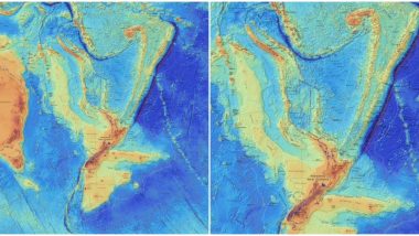
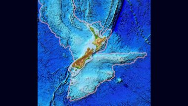
Did you know that the earth has the eighth continent? No, your childhood hasn't missed any major part as this part of the land was discovered recently, in the year 2017. Called as Zealandia, it has its own continent status but it in a major update, scientists have revealed new maps which show more details about this hidden piece of land beneath the Pacific Ocean. Zealandia has 95% of its land underwater. But now there's a dedicated website which will let you explore more about this continent. Read on to know more about Zealandia. Giant Circles of Shafts Found Near Stonehenge! Prehistoric Monument Dating Back to 4500 Years Discovered in UK (Watch Video).
Also called as Te Riu-a-Māui, it is about 5 million square kilometres located beneath modern-day New Zealand. Only 6% of it is above sea level. Because of its underwater status, it has not been studied in-depth or not many people know about it. GNS Science. a research and consultancy organisation from New Zealand have made available new maps of Zealandia which reveal more of the continent. These maps are up on an interactive website so users can virtually explore it.
Talking about the new development lead author of the maps, geologist Dr Nick Mortimer said, "We’ve made these maps to provide an accurate, complete and up-to-date picture of the geology of the New Zealand and southwest Pacific area - better than we have had before." A user can navigate across Zealandia by zooming in on these maps. You can get a customised view by turning off the layers, features of which are also given here. You can also see the tectonic plates and territorial sea of the continent.
Check Pics of the Maps Here:
Te Riu-a-Māui / Zealandia - we have released two maps and a website. The maps cover the bathymetry (shape of the ocean floor) and the tectonic origins of Earth’s eighth continent.https://t.co/6Aac474VD9 pic.twitter.com/fL62BwepCh
— Te Pū Ao - GNS Science (@gnsscience) June 23, 2020
Here's a Tectonic Map:
There has been a lot of interest in the Te Riu-a-Māui/Zealandia tectonic & bathymetric maps we launched earlier this week. A video of the seminar to support the launch is now available with speakers from LINZ, NIWA and GNS Science.https://t.co/26dOB5FRI4 pic.twitter.com/WqX5gjTn28
— Te Pū Ao - GNS Science (@gnsscience) June 26, 2020
These maps reveal the crust of Earth forming the landmass of this continent, the oceanic and continental. It also shows where the volcanoes are. Zealandia sits on various tectonic plates. More study on them could reveal how this continent was formed. These new maps have been called as a "scientific benchmark." If geology fascinates you, then start exploring the earth's little known secret.
(The above story first appeared on LatestLY on Jun 27, 2020 12:53 PM IST. For more news and updates on politics, world, sports, entertainment and lifestyle, log on to our website latestly.com).








 Quickly


