Ocean warming is creating stronger tropical storms. Hurricane Beryl strengthened to Category 3 as it approached Mexico's Yucatán peninsula.Atlantic hurricane seasons have only been getting worse.
Also Read | Firefly Aerospace Launches Alpha Flight 5 Rocket Carrying 8 CubeSat Small Satellites for NASA.
In late May 2024, the US National Oceanic and Atmospheric Administration (NOAA) predicted "an 85% chance of an above-normal" season.
Also Read | Should We Be Concerned About a Summer COVID Surge?.
When Hurricane Beryl formed as the first of a five-month season, the NOAA called it an "explosive start."
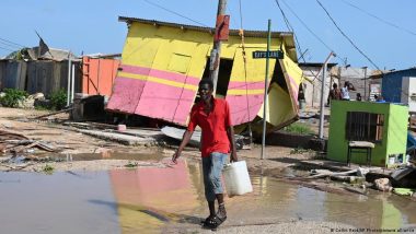
After Beryl had struck Jamaica, causing widespread destruction, it moved to Mexico's Yucatán peninsula.
At the United Nations' weather and climate agency (WMO), scientists said Beryl had set "an alarming precedent for what is expected to be a very active hurricane season." The season officially runs from June 1 to November 30 — it's a year-on-year threat in the Atlantic and eastern Pacific.
Anne-Claire Fontan, a scientific officer at the WMO's tropical cyclone program, told the AFP news agency, that Beryl had developed into a category 5 storm very early in the season. "It's really very unusual. Hurricane Beryl really broke records," said Fontan.
But these are new records, because it was only in October 2023 that Hurricane Otis broke a few records of its own.
Hurricanes are intensifying faster
Extreme weather researchers say hurricanes are getting stronger because of climate change.
Tropical cyclones gain most of their energy from the evaporative heat of the water vapor they pick up over the ocean.
With ocean surface temperatures rising, hurricanes are absorbing more water vapor faster, according to an analysis recently published in the journal Scientific Reports.
Along with increasing the intensity of hurricanes, the trend is making it harder for meteorologists to reliably predict when and where hurricanes will strike.
Recipe for a hurricane
Typhoon, hurricane and cyclone — all three describe the same extreme weather: the tropical cyclone.
The weather phenomenon is referred to as a typhoon off East and Southeast Asia, a cyclone off India and Australia and a hurricane off the coast of North America.
Regardless of what you call them, these storms all form in the same way: when water over 26 degrees Celsius (79 Fahrenheit) evaporates over the sea.
Tornadoes are the "land" equivalent of these water-based cyclones.
Unlike hurricanes, tornadoes can develop wherever there are thunderstorms.
Local temperature differences cause warm air to push upward, cold air to plummet and a column of warm air to spiral upward faster and faster. Tornadoes typically have a diameter of less than a kilometer.
Hurricanes are high-maintenance
"Hurricanes need a number of basic conditions to be able to form," said Andreas Friedrich, meteorologist and tornado officer at the German Weather Service.
Along with the sea-surface temperature requirement of at least 26 degrees Celsius, this warm-water area must be large enough for a hurricane to form — several hundreds of square kilometers.
And hurricanes can't develop without the presence of a low-pressure area.
"Often, small low-pressure areas move from the west coast of Africa with the monsoon current across the Atlantic into these warm waters," said Friedrich.
A hurricane can only form, he added, when there are no large wind differences near the surface of the sea or at higher altitudes — these would drive the storm apart.
Destructive mixture
If everything comes together, a low-pressure area can develop into a hurricane.
Warm, humid air from the sea rises to condense at colder altitudes, forming thunderclouds and negative pressure on the sea's surface. Air from the surrounding area is drawn into the storm en masse.
Then, these air masses are pulled upwards like in a chimney, generating wind speeds of up to 350 kilometers per hour.
The Coriolis force — related to Earth's spin — sets the masses in rotation.
"In the center of this vortex, the typical 'eye' of a hurricane is formed, where it is completely calm and cloudless, while the clouds at the edge of the eye pile up higher and higher," Friedrich said.
Slow-moving storms are more devastating
The longer these favorable hurricane conditions persist, the more destructive the storm becomes.
"Hurricanes move with the help of air currents at an altitude of 5 to 8 kilometers. They determine where the hurricane moves," said Friedrich.
When the hurricane hits a coast, it usually loses power quickly: the air currents in the higher atmosphere quickly drive the storm inland, cutting it off from its main source of energy — warm, moist ocean air. There, they weaken into low-pressure systems, losing their destructive power.
However, if a tropical cyclone moves very slowly and continues being fed with moist ocean air near the coast, it can cause severe damage.
Stronger hurricanes due to climate change
Higher sea surface temperatures are creating better conditions for hurricanes, Friedrich stressed.
"The larger the ocean areas with temperatures above 26 degrees, the larger the areas where hurricanes can form," he said. Climate models suggest there will not only be more hurricanes in the future, but also stronger ones, he added.
The Scientific Reports analysis appears to support this: according to the analysis, hurricanes today are more than twice as likely to develop from a weak (Category 1) hurricane to a strong (Category 3 or more) hurricane within 24 hours.
In addition, the regions where tropical cyclones occur in the Atlantic and Caribbean also shifted in response to the warming of the ocean during the study period.
The original article, published in German in 2020, was translated and revised on October 27, 2023, then updated in July 2024, with details on Hurricane Beryl.
(The above story first appeared on LatestLY on Jul 05, 2024 04:10 PM IST. For more news and updates on politics, world, sports, entertainment and lifestyle, log on to our website latestly.com).


 Quickly


