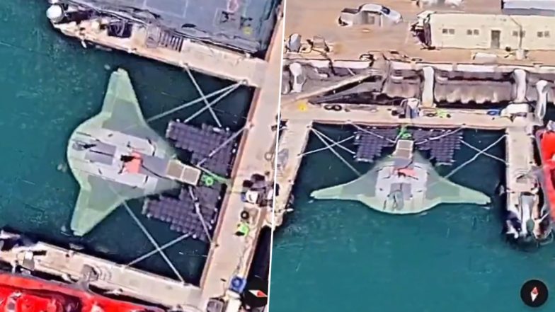
Manta Ray, a top-secret US aquatic drone, was spotted resting at the Port Hueneme naval base in California by Google Maps users on Sunday. The Google Maps users made this discovery while exploring the coasts around Naval Base San Diego. GMap users then shared the screenshots and screenrecordings of the same on social media. The Manta Ray lives up to its name, resembling the graceful sea creature. Its streamlined form allows it to glide effortlessly through the depths, while its ability to anchor itself deep underwater ensures stealthy operations. Produced by defence contractor Northrop Grumman, the Manta Ray is part of a US Navy initiative to develop long-range underwater weapons. Red Sea Crisis: US Destroyer Shoots Down Missile and Drones Launched by Yemen's Houthi Rebels.
Manta Ray Spotted on Google Maps?
Google Maps users have discovered a top-secret prototype of the American naval drone Manta Ray at a base in California.
The images have started circulating on social media and can still be found on Google Maps.
One of the unique features of the drone, developed by Northrop… pic.twitter.com/br7wzWFnPR
— Sputnik (@SputnikInt) June 25, 2024
User Shares Video
Someone managed to find the DARPA Manta Ray on google maps
Coordinates
34°09'12"N 119°12'31"W pic.twitter.com/uMdDj2dMsO
— nikola 3 (@ronin19217435) June 20, 2024
(SocialLY brings you all the latest breaking news, fact checks and information from social media world, including Twitter (X), Instagram and Youtube. The above post contains publicly available embedded media, directly from the user's social media account and the views appearing in the social media post do not reflect the opinions of LatestLY.)


 Quickly


