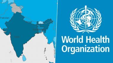
New Delhi, February 4: Minister of State for External Affairs, V Muraleedharan on Thursday informed Rajya Sabha that the issue pertaining to wrong depiction of Indian map on the official website of the World Health Organisation was 'strongly raised' with the world health regulator. In response to it, WHO has informed Permanent Mission of India in Geneva that they've put a disclaimer on portal in regard of depiction of territories and areas belonging to any country.
In the disclaimer of its official website, the World Heath Organisation says "designations employed and presentation of these materials don't imply expression of any opinion on part of WHO concerning legal status of any country,territory or area or of its authorities or concerning legal status of any country,territory or area of its authorities or concerning delimitation of its frontiers or boundaries." WHO Map Marks Jammu & Kashmir, Ladakh With Colours 'Different' Than Rest of India, Draws Flak.
An India map on the coronavirus disease (COVID-19) dash board on WHO's official website shows the newly formed territories of Jammu and Kashmir and Ladakh with a colour different from the one used to mark the rest of India. Pakistan Includes Indian Territories in New Political Map, India Calls It an Exercise in 'Political Absurdity.'
In the map, the entire country has been depicted through navy blue colour, however Jammu and Kashmir and Ladakh are shown with grey colour. The disputed border area of Aksai Chin is demarcated with grey with blue stripes, the same shade as that of China.
(The above story first appeared on LatestLY on Feb 04, 2021 12:03 PM IST. For more news and updates on politics, world, sports, entertainment and lifestyle, log on to our website latestly.com).


 Quickly


