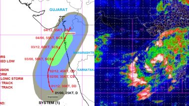
New Delhi, June 2: Nisarga cyclone has now moved even more closer to Goa, Mumbai and Surat on Tuesday, the India Meteorological Department (IMD) said in its weather bulletin. Giving the present location of the cyclonic storm, the IMD said the depression over Eastcentral Arabian Sea lies about 300 km west-southwest of Panjim, 550 km south-southwest of Mumbai and 770 km south-southwest of Surat, as per IMD update at 2.30 AM today. Nisarga Cyclone Tracker: Cyclonic Storm to Turn Into Severe Cyclonic Storm by June 3; Check Forecast and Day-Wise Movement.
The depression is set to intensify into a 'Deep Depression' by Tuesday afternoon and intensify further into a 'Cyclonic Storm' over the Arabian Sea during next 12 hours. The storm is very likely to cross north Maharashtra & south Gujarat coasts between Harihareshwar in Maharashtra and Daman in Gujarat by the afternoon on June 3.
Here's the tweet:
Depression over Eastcentral Arabian Sea lay near latitude 14.4°N and longitude 71.2°E about 300 km west-southwest of Panjim, 550 km south-southwest of Mumbai and 770 km south-southwest of Surat, as per IMD update at 2.30 AM today: Govt of India pic.twitter.com/a58SnwmvKb
— ANI (@ANI) June 2, 2020
In the wake of the current weather conditions, light to moderate rainfall is expected over Lakshadweep, north Kerala and coastal Karnataka during next 12 hours. Light to moderate rainfall at most places with heavy to very heavy falls at isolated places very likely over south Konkan & Goa during June 2 and June 3. Meanwhile, heavy rainfall is very likely over south Gujarat state, Daman, Dadra & Nagar Haveli on June 3 and with heavy to very heavy rainfall at a few places and extremely heavy falls at isolated places over south Gujarat region, Daman, Dadra & Nagar Haveli on June 4.
(The above story first appeared on LatestLY on Jun 02, 2020 09:04 AM IST. For more news and updates on politics, world, sports, entertainment and lifestyle, log on to our website latestly.com).


 Quickly


