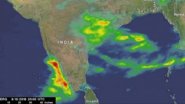
Washington, Aug 22: NASA has released a video created using satellite data that provides an estimate of the intense rainfall over India in the past week and shows the spread of the resulting severe flooding in Kerala and parts of Karnataka.
The summer monsoon is a regular feature this time of year in India, and it can bring heavy rains to the region. However, periodically areas of low pressure can form within the general monsoon trough and bring even more rain.
Kerala is facing its worst floods in nearly a century that has left at least 231 people dead, and forced 3.14 lakh people out of their homes. The Centre has declared this calamity of 'severe nature'.
Rainfall accumulations from August 13 to 20 showed two bands of heavy rain across India, NASA said in a statement. The first band appeared much broader and extends across the northern part of the peninsula with weekly rainfall totals ranging from over 5 inches towards the western half of the peninsula to as much as 14 inches over parts of the eastern half towards the Bay of Bengal.
The first band is associated with the general monsoon circulation. The second band appeared more concentrated and intense and is closely aligned with the southwest coast of India and the Western Ghats where onshore flow was enhanced by an area of low pressure embedded within the general monsoon.
Weekly rainfall totals in this band are generally over 10 inches with embedded areas exceeding 16 inches. The maximum estimated value from the data in this band was 18.5 inches, NASA said.
Although the extreme Himalayan topography is much more well-known, another contributing factor to the heavy rains along the southwest coast of India is the Western Ghats, it said.
Though much smaller than the Himalayas, this mountain range runs parallel to the West Coast of India with many peaks over 2,000 metres. As a result, the Western Ghats are well positioned to enhance rainfall along the West Coast of India as they intercept the moisture-laden air being drawn in off the warm waters of the northern Indian Ocean and the Arabian Sea as part of the southwest monsoon circulation.
The Integrated Multi-satellitE Retrievals for GPM (IMERG) is used to estimate precipitation from a combination of passive microwave sensors, including microwave sensor and infrared data.
The data is generated every half an hour, thereby allowing scientists to track rainfall across the globe almost in real time. GPM is the Global Precipitation Measurement mission core satellite. GPM is a joint mission between NASA and the Japan Aerospace Agency, JAXA.


 Quickly


