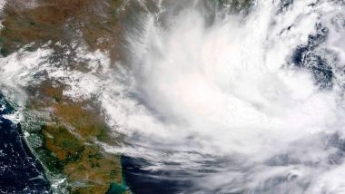
New Delhi, May 6: The Low Pressure Area (LPA), formed over South Andaman Sea, is likely to intensify into a depression by Saturday evening and further into a cyclonic storm by Sunday evening, the IMD said on Friday.
The India Meteorological Department (IMD) had earlier in the morning said the LPA was very likely to move northwards and intensify into a depression during the next 48 hours.
The PA formed over South Andaman Sea and adjoining southeast Bay of Bengal after intensifying into a cyclonic storm is very likely to continue to move northwestwards and reach west-central Bay of Bengal off north Andhra-Odisha coasts by May 10.
Under its influence, scattered to fairly widespread light/moderate rainfall is very likely over Arunachal Pradesh, Assam, Meghalaya, Nagaland, Manipur, Mizoram, and Tripura during next five days with isolate thunderstorm/lightning over Assam and Meghalaya till May 8. Odisha Says Ready to Face Eventuality of Cyclone.
The IMD also predicted that isolated heavy rainfall is very likely over Arunachal Pradesh, Nagaland, Manipur, Mizoram, and Tripura on May 10 and over Assam, and Meghalaya on May 9 and 10.
It has also forecast squally wind speed reaching 40-50 kmph gusting to 60 kmph very likely to prevail over South Andaman Sea and adjoining southeast Bay of Bengal and Andaman and Nicobar Islands for next three days and warned fishermen not to venture into the Andaman Sea and southeast Bay of Bengal that are likely to be rough to very rough.
From the perspective of better disaster management till May 8, the Andaman and Nicobar Islands administration has been asked to totally suspend fishing and tourism activities and for communities, the warnings have asked people to avoid going to areas that face the water logging problems often.
(The above story first appeared on LatestLY on May 06, 2022 11:16 PM IST. For more news and updates on politics, world, sports, entertainment and lifestyle, log on to our website latestly.com).


 Quickly


