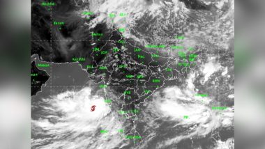
Ahmedabad, June 17: Cyclone Vayu, which lay centered over northeast Arabian Sea on Monday, will weaken into a deep depression during the next six hours and into a depression in subsequent 12 hours, the India Meteorological Department (IMD) said in its weather bulletin. The IMD added saying that it is likely to move northeastwards and cross north Gujarat coast by midnight of 17th June, 2019 as a depression. The intensity of depression and deep depression is much less. They bring a good amount of rain with reduced wind intensity. How Cyclone Vayu Got Its Name And What Next Cyclone Will Be Called, Know All About How Cyclonic Storms Are Named.
"Cyclonic storm Vayu lay centered at 0530 hrs IST today over Northeast Arabian Sea & neighborhood, about 280 Km west-southwest of Naliya, 260 Km west-southwest of Dwarka & 360 Km west-southwest of Bhuj in Gujarat", the IMD said in its release. Cyclone Vayu To Make Landfall on June 13 Between Veraval And Mahuva; Gujarat on High Alert.
The IMD said the cyclone is likely to gradually weaken into a cyclonic storm during the next 24 hours before it recurves and crosses the Gujarat coast by Monday midnight. Earlier on Sunday, the IMD had said that cyclone Vayu was moving away from the Gujarat coast.The IMD director Jayant Sarkar also assured that the Cyclone will not cause any substantial damage in the areas where it will come.
The IMD also forecast heavy rains at isolated places in Saurashtra-Kutch regions on Monday, and heavy to very heavy rains in north Gujarat and the districts in Saurashtra-Kutch on Tuesday.
(The above story first appeared on LatestLY on Jun 17, 2019 09:50 AM IST. For more news and updates on politics, world, sports, entertainment and lifestyle, log on to our website latestly.com).


 Quickly


