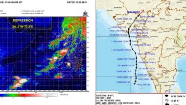
New Delhi, May 19: Cyclone "Tauktae" is very likely to move north-eastwards and weaken gradually into a well-marked low-pressure area during next 12 hours, the India Meteorological Department said.
Remnant of the system is very likely to move further north-eastwards across Rajasthan to west Uttar Pradesh during the next two days, said National Weather Forecasting Centre of the India Meteorological Department (IMD).
The deep depression (remnant of the extremely severe cyclonic storm Tauktae) over Gujarat region moved north-eastwards with a speed of about seven kmph during past six hours, weakened into a depression and lay centered at 5.30 a.m. on Wednesday near latitude 24.3 degree north and longitude 73.3 degree east over south Rajasthan and adjoining Gujarat region, about 60 kms west-southwest of Udaipur (Rajasthan) and 110 km east-northeast of Deesa (Gujarat region). Cyclone Tauktae Weakens Into a Depression, Heavy Rainfall Expected in Gujarat, Rajasthan, Delhi and Other Northern States.
Light to moderate rainfall at most places with heavy to very heavy rainfall at isolated places is very likely over east Rajasthan on Wednesday.
The interaction of the remnant low pressure system with a trough in westerlies associated with a Western Disturbance is very likely to cause light to moderate rainfall at most places with heavy to very heavy falls and extremely heavy falls at isolated places over Uttarakhand, heavy to very heavy rainfall at isolated places over Himachal Pradesh, Haryana, Chandigarh and Delhi, West Uttar Pradesh and Heavy rainfall at isolated places over Punjab, East Uttar Pradesh, north Madhya Pradesh and West Rajasthan during next 24 hours.
Squally wind speed reaching 45-55 kmph gusting to 65 kmph is likely to prevail over east Rajasthan and adjoining Gujarat region during next 12 hours, the IMD said.
(The above story first appeared on LatestLY on May 19, 2021 11:53 AM IST. For more news and updates on politics, world, sports, entertainment and lifestyle, log on to our website latestly.com).


 Quickly


