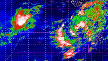
Mumbai, June 2: As the storm brewing in the Arabian Sea intensified into a tropical cyclone Nisarga on Tuesday morning, many experts believe its landfall would be a rarest of rare events on the Maharashtra coastline. The last cyclone to hit Mumbai was cyclonic storm 'Phyan' on November 11, 2009. Nisarga is currently located around 400 km from Mumbai as a deep depression. What is a Cyclone? Know All About Cyclonic Storms Ahead of 'Nisarga', Which is Expected to Make Landfall at Maharashtra Coast Near Alibaug On June 3.
The India Meteorological Department (IMD) has predicted that the cyclonic storms will strengthen into severe cyclonic storms and cross Maharashtra and Gujarat coast between Harihareshwar and Daman, close to Alibag in Maharashtra's Raigad district on Wednesday afternoon.
According to IMD's Cyclone E-Atlas, no weather system has turned into a cyclone and made landfall along the Maharashtra coast during June. Cyclone E-Atlas has been tracking tropical cyclones and depressions over the North Indian Ocean since 1891.
Echoing it, Roxy Mathew Koll, a climate scientist at the Indian Institute of Tropical Meteorology (IITM), said, "The cyclone Nisarga is about to scrape around Mumbai on June 3. If that happens, it will be the first cyclone in the recorded history to hit the Maharashtra coast in June." When Will Cyclone Nisarga Hit Mumbai? What Will be The Wind Speed Over Next 2 Days? Here's What IMD Has Said.
Another IITM researcher said it would be the "second cyclone" in the recorded history to hit the Maharashtra coast in the pre-monsoon season (April-June). "The only cyclone that hit the Maharashtra coast in the pre-monsoon season was in May 1961," Vineet Kumar said.
According to the National Cyclone Risk Mitigation Project, only 25 per cent cyclones that develop in the Arabian Sea approach the West Coast. Senior Meteorologist Jason Nicholls said, "only three cyclonic storms have made landfall over or near Mumbai since 1891, and all three occurred in October and November. The latest was Phyan in 2009."
The number of cyclones and severe cyclones in the Arabian Sea has risen by nearly 32 per cent in the last five years, according to the IMD data. The cyclonic storm is currently located 280 km west-southwest of Panjim (Goa), 430 km south-southwest of Mumbai (Maharashtra) and 640 km south-southwest of Surat (Gujarat).
It will make a landfall with a wind speed of 100-110 kmph gusting to 120 kmph. The storm surge is expected to be one-two metres above the astronomical tide and is likely to inundate low-lying areas of Mumbai, Thane and Raigad districts at the time of landfall.
(The above story first appeared on LatestLY on Jun 02, 2020 06:40 PM IST. For more news and updates on politics, world, sports, entertainment and lifestyle, log on to our website latestly.com).


 Quickly


