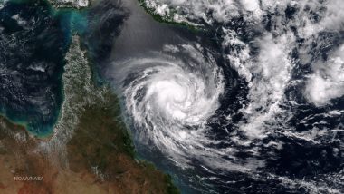
New Delhi, June 6: A depression over the southeast Arabian Sea, south of Porbandar in Gujarat, is likely to move northwestward and intensify into a cyclonic storm, the India Meteorological Department said on Tuesday. The cyclonic storm will be called Cyclone Biparjoy, a name given by Bangladesh.
In a bulletin, the Met office said the depression lay about 950 km west-southwest of Goa, 1,100 km south-southwest of Mumbai, 1,190 km south of Porbandar and 1,490 km south of Karachi, Pakistan, at 8:30 am. Cyclone Biparjoy Live Tracker Map.
"It is likely to move nearly northwards and intensify into a cyclonic storm during over east-central Arabian Sea and adjoining southeast Arabian Sea," it said. The Met office said the cyclonic storm will intensify into a severe cyclonic storm by Thursday morning and very severe cyclonic storm by Friday evening.
Sea conditions are likely to be very high along and off the Kerala-Karnataka coasts and Lakshadweep-Maldives areas on June 6 and Konkan-Goa-Maharashtra coasts from June 8 to June 10. Fishermen out at sea have been advised to return to the coast.
The IMD had Monday said the formation of the low-pressure system over the southeast Arabian Sea and its intensification is expected to critically influence the advance of the monsoon towards the Kerala coast.
The weather department, however, did not give a tentative date for the arrival of the monsoon in Kerala. Private forecasting agency Skymet Weather said the monsoon onset over Kerala may happen on June 8 or June 9 but it is expected to be a "meek and mild entry".
"These powerful weather systems in the Arabian Sea spoil the advancement of the monsoon deep inland. Under their influence, the monsoon stream may reach coastal parts but will struggle to penetrate beyond the Western Ghats," it said. Cyclone Biparjoy Latest News Updates: IMD Says Depression Over Arabian Sea Likely To Intensify Into Cyclonic Storm, Mumbai May Receive Heavy Rainfall on These Dates.
Skymet had earlier predicted the monsoon onset over Kerala on June 7 with an error margin of three days. "The southwest monsoon is likely to arrive within this bracket. Onset criteria require stipulated rainfall on two consecutive days over Lakshadweep, Kerala and coastal Karnataka. Accordingly, the spread and intensity of rainfall may match these requirements on June 8 or June 9.
However, the onset of the annual event may not be loud and sound. It may only make a meek and mild entry to start with," the private weather forecasting agency said. D S Pai, senior scientist, IMD, said Kerala received good rain on Monday too and conditions are favourable for the onset of monsoon over the next two to three days.
Southern peninsula will get rain under the influence of the cyclonic storm and a low-pressure system developing in the Bay of Bengal. However, further progress of the monsoon beyond the southern peninsula will happen after the cyclone degenerates, Pai said.
The southwest monsoon normally sets in over Kerala on June 1 with a standard deviation of about seven days. In mid-May, the India Meteorological Department (IMD) said monsoon might arrive in Kerala by June 4. The southeast monsoon arrived in the southern state on May 29 last year, June 3 in 2021, June 1 in 2020, June 8 in 2019 and May 29 in 2018.
Scientists say a slightly delayed onset over Kerala does not mean that the monsoon will reach other parts of the country late. It also does not impact the total rainfall over the country during the season.
India is expected to get normal rainfall during the southwest monsoon season despite the evolving El Nino conditions, the IMD had earlier said. Northwest India is expected to see normal to below-normal rainfall. East and northeast, central, and south peninsula are expected to receive normal rainfall at 94-106 per cent of the long-period average of 87 centimetres.


 Quickly


