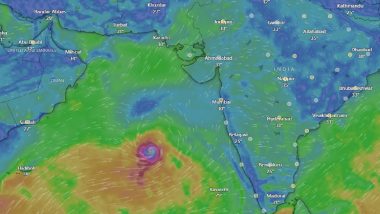
New Delhi, Jun 8: Cyclone 'Biparjoy', the first storm brewing in the Arabian Sea this year, rapidly intensified into a very severe cyclonic storm with meteorologists predicting a "mild" monsoon onset over Kerala and "weak" progress beyond the southern peninsula under its influence. The India Meteorological Department (IMD) on Wednesday morning said conditions are favourable for monsoon onset over Kerala within two days.
Meteorologists, however, said the cyclone has been impacting the intensity of the monsoon and the onset over Kerala would be "mild". The MeT office said the very severe cyclonic storm would intensify further and move northwards during the next three days. However, the IMD has not yet predicted any major impact on countries adjoining the Arabian Sea, including India, Oman, Iran and Pakistan. Meteorologists say the tentative track of the system will be in the northward direction but storms at times defy the predicted track and the intensity. Cyclone Biparjoy Live Tracker Map on Windy: Depression Over Arabian Sea Likely to Intensify Into Cyclonic Storm, Mumbai May Receive Heavy Rainfall; Check Real-Time Status.
Forecasting agencies said the storm has been undergoing "rapid intensification", escalating from just a cyclonic circulation to a very severe cyclonic storm in just 48 hours, defying earlier predictions. Atmospheric conditions and cloud mass indicate that the system is likely to sustain the strength of a very severe cyclone till June 12. Scientists say cyclonic storms in the Bay of Bengal and the Arabian Sea have been intensifying rapidly and retaining their intensity for a longer duration due to climate change.
According to a study 'Changing status of tropical cyclones over the north Indian Ocean', the frequency, duration, and intensity of cyclones in the Arabian Sea have increased by about 20 per cent in the post-monsoon period and 40 per cent in the pre-monsoon period. There has been a 52 per cent increase in the number of cyclones in the Arabian Sea, while very severe cyclones have increased by 150 per cent. Monsoon 2023 Tracker in India: Cyclonic Storm Biparjoy May Delay Rain in India.
"The increase in cyclone activity in the Arabian Sea is tightly linked to the rising ocean temperatures and increased availability of moisture under global warming. The Arabian Sea used to be cool, but now it is a warm pool," Roxy Mathew Koll, climate scientist at the Indian Institute of Tropical Meteorology, said.
"The oceans have become warmer already on account of climate change. In fact, a recent study shows that the Arabian Sea has warmed up by almost 1.2 degrees Celsius since March, thus conditions are very much favourable for the rapid intensification of the system (Cyclone Bipajoy) so it has potential to sustain the strength for a longer period," Raghu Murtugudde, Professor, Department of Atmospheric and Oceanic Science, University of Maryland and IIT Bombay, said.
Mahesh Palawat, vice president (climate and meteorology) Skymet Weather, said the cloud mass is concentrated around this system and enough moisture is not reaching the Kerala coast. Though the criteria for monsoon onset can be met in the next two days, it will not be a thumping start. After the onset over Kerala, the monsoon will remain "weak" until the storm degenerates around June 12, he said.
"The powerful weather system in the Arabian Sea may spoil the advancement of the monsoon deep inland. Under their influence, the monsoon stream may reach coastal parts, but will struggle to penetrate beyond the Western Ghats," Skymet Weather had said on Tuesday. A senior IMD scientist said the southern peninsula will get rain under the influence of the cyclonic storm and a low-pressure system developing in the Bay of Bengal.
However, further progress of the monsoon beyond the southern peninsula will happen after the cyclone degenerates. "It would not be the case of classic monsoon onset, satisfying all the given criteria. We would have scattered rains along the West Coast strip, but no inland penetration and widespread rains," Koll said. The southwest monsoon normally sets in over Kerala on June 1 with a standard deviation of about seven days. In mid-May, the IMD said monsoon might arrive in Kerala by June 4.
Skymet had predicted the monsoon onset over Kerala on June 7 with an error margin of three days. Over the last 150 years, the date of monsoon onset over Kerala has varied widely, the earliest being May 11, 1918 and the most delayed being June 18, 1972, according to IMD data. The southwest monsoon arrived in the southern state on May 29 last year, June 3 in 2021, June 1 in 2020, June 8 in 2019 and May 29 in 2018.
Research shows a delay in the monsoon onset over Kerala (MOK) does not necessarily mean a delay in the monsoon onset over northwest India. However, a delay in the MOK is generally associated with a delay in onset at least over the southern states and Mumbai. Scientists say a delayed MOK also does not impact the total rainfall over the country during the season. India is expected to get normal rainfall during the southwest monsoon season despite the evolving El Nino conditions, the IMD had earlier said.
Northwest India is expected to see normal to below-normal rainfall. East and northeast, central, and south peninsula are expected to receive normal rainfall at 94-106 per cent of the long-period average of 87 cm. Rainfall less than 90 per cent of the long-period average is considered 'deficient', between 90 per cent and 95 per cent is 'below normal', between 105 per cent and 110 per cent is 'above normal' and more than 100 per cent is 'excess' precipitation.
Normal rainfall is critical for India's agricultural landscape, with 52 per cent of the net cultivated area relying on it. It is also crucial for replenishing of reservoirs critical for drinking water apart from power generation across the country. Rainfed agriculture accounts for about 40 per cent of the country's total food production, making it a crucial contributor to India's food security and economic stability.


 Quickly


