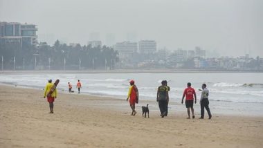
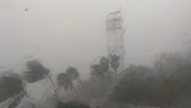
Cyclone Tauktae has now intensified into an 'extremely severe cyclonic storm with gale-force winds, heavy rainfall and high tidal waves sweeping the coastal belt of Kerala, Karnataka, Goa and now Maharashtra. Tropical Cyclone Tauktae hurtled northwards towards Gujarat on Sunday, May 17, damaging hundreds of houses, uprooting electricity poles and trees, and forcing evacuation in low-lying areas across regions located near the coastal belt.
According to the Cyclone Warning Division of the IMD, by May 18 the wind speed is expected to increase to 150-160 km per hour, gusting up to 175 km per hour. According to the India Meteorological Department (IMD), Tauktae Cyclone is likely to intensify further and reach the Gujarat coast on Monday evening. Cyclone Tauktae Live Tracker Map on Windy: Tropical Cyclonic Storm to Hit Coast of Gujarat Today; Check Realtime Status Here
What is a cyclone?
A cyclone is a term for a weather system in which the winds rotate inwardly to an area of low atmospheric pressure. In meteorology, a cyclone is a large-scale air mass that rotates around a strong center of low atmospheric pressure. It rotates counterclockwise in the Northern Hemisphere and clockwise in the Southern Hemisphere. Types of cyclones include tropical cyclones, extratropical cyclones and tornadoes.
Cyclones are characterized by inward-spiraling winds that rotate about a zone of low pressure. The largest low-pressure systems are polar vortices and extratropical cyclones of the largest scale (the synoptic scale). Warm-core cyclones such as tropical cyclones and subtropical cyclones also lie within the synoptic scale. Cyclone Tauktae Day-Wise Forecast: Cyclonic Storm To Cross Gujarat Coast on May 18; Check Cyclone Path, Wind Speed and Intensity.
Take a look at Dos and Don'ts for Cyclone:
DOs
- When there is a possibility of a cyclone, the first thing you need to do is check houses, secure loose tiles by cementing wherever necessary, repair doors and windows.
- Check the area around the house. Remove dead or dying trees, anchor removable objects like lumber piles, loose bricks, garbage cans, sign-boards, loose zinc sheets etc.
- Keep some wooden boards ready so that glass windows can be boarded.
- If you do not have wooden boards handy, paste paper strips on glasses to prevent splinters from flying into the house.
- Keep a hurricane lantern filled with kerosene, flashlight and enough dry cells and keep them handy.
- Promptly demolish condemned buildings. Those who have radio sets should ensure that the radio is fully serviceable. In the case of transistors, an extra set of batteries should be kept handy.
- Keep your radio on and listen to latest weather warnings and advisories from the nearest AIR station. Pass the information to others.
- Pass only the official information you have got from the radio to others.
- Get away from low lying beaches or other locations which may be swept by high tides or storm waves. Leave sufficiently early before your way to high ground gets flooded. Do not delay and run the risk of being marooned.
- If your house is out of danger from high tides and flooding from the river, and it is well built, it is then probably the best place. However, please act promptly if asked to evacuate.
- Be alert for high water in areas where streams of rivers may flood due to heavy rains.
- Get extra food, especially things which can be eaten without cooking or with very little preparation. Store extra drinking water in suitably covered vessel.
- If you are in one of the evacuation areas, move your valuable articles to upper floors to minimise flood damage
- Check on everything that might blow away or be torn loose. Kerosene tins, cans, agricultural implements, garden tools, road signs and other objects become weapon of destruction in strong winds. Remove them and store them in a covered room.
- Be sure that a window or door can be opened on the lee side of the house i.e. the side opposite the one facing the wind.
- Make provisions for children and adults requiring special diets.
- If the centre of' ‘eye' of the storm passes directly over your place, there will be a lull in the wind and rain, lasting for half an hour or more. During this period stay in safe place. Make emergency repairs during the lull period if necessary, but remember that strong wind will return suddenly from the opposite direction, frequently with even greater violence.
- Be calm. Your ability to meet emergency will inspire and help others.
- You should remain in shelters until informed by those in charge that you may return home.
- Any loose and dangling wire from the lamp post should be strictly avoided.
- People should keep away from disaster areas unless you are required to assist.
- Anti-social elements should be prevented from doing mischief and reported to the police.
- Cars, buses, lorries and carts should be driven carefully. The houses and dwellings should be cleared of debris. The losses should be reported to the appropriate authorities.
- Relatives should be promptly informed about the safety of persons in the disaster area.
Don’ts
- Avoid being misled by rumours.
- Don’t leave shelters until informed by the rescue personals.
- Don’t leave the safer place during lull, however minor repairs can be carried out.
- Don’t touch the loose and dangling wire from lamp post, it may have electric current.
Apart from the Dos and Don'ts mentioned above, the National Disaster Management Authority (NDMA) has also issued a list of do's and don'ts for dealing with Cyclone Tauktae.
Check Dos and Don'ts for Cyclone issued by NDMA:
Be Smart Be Prepared!#Cyclone Do's and Dont's #cyclonetauktae pic.twitter.com/EErSECQbje
— NDMA India | राष्ट्रीय आपदा प्रबंधन प्राधिकरण 🇮🇳 (@ndmaindia) May 13, 2021
Cyclone Tauktae will cross the Gujarat coast between Porbandar and Mahuva (Bhavnagar district) during early hours on Tuesday as a very severe cyclonic storm with a maximum sustained surface wind speed of 155-165 kmph gusting to 185 kmph. The IMD has warned that Cyclone Tauktae will take an extreme shape in the east central Arabian Sea by Monday night, with wind speed reaching 180-190 kmph gusting to 210 kmph likely to prevail during the next six hours.
Home Minister Amit Shah reviewed the preparedness for Cyclone Tauktae in Gujarat, Maharashtra and the Union territories of Daman and Diu and Dadra and Nagar Havel and "specifically" stressed that all health facilities, including those for COVID-19 treatment, falling in the affected areas should be secured along with the patients.
(The above story first appeared on LatestLY on May 17, 2021 01:39 PM IST. For more news and updates on politics, world, sports, entertainment and lifestyle, log on to our website latestly.com).


 Quickly


