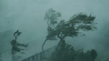
Tokyo, Sep 6: The second powerful typhoon to slam Japan in a week unleashed fierce winds and rain on southern islands on Sunday, blowing off rooftops and leaving homes without power as it edged northward into an area vulnerable to flooding and mudslides.
Weather officials warned that rainfall from what could be a record storm would be as fierce as a bucket of water poured over your head. Warnings have been issued, days in advance, for people to be ready to take shelter and stock up on food and water.
Also Read | Shaheena Shaheen Baloch, Pakistani Journalist, Shot Dead in Turbat.
Several rivers on the main southwestern island of Kyushu were at risk of overflowing, officials said.
The Japan Meteorological Agency said Typhoon Haishen, which means “sea god” in Chinese, was packing sustained winds of up to 180 kilometers (112 miles) per hour as it battered Okinawa and the southern Kyushu island of Amami Oshima early Sunday.
Also Read | COVID-19 Tally: India Crosses Brazil, Becomes Country With 2nd Highest Caseload, Shows Worldometers Tracker.
Alerts for strong winds, waves, high tides, rainfall and lightning were issued for Amami Oshima alongside evacuation orders.
Haishen was not only powerful — equivalent to a Category 3 hurricane — but also large in its reach in areas affected, according to the agency. Haishen's course is similar to Typhoon Maysak that lashed southern Japan last week, injuring dozens of people and cutting power to thousands of homes.
A cargo ship carrying 43 crew members and 5,800 cows from New Zealand capsized off the coast of Japan. Two people were rescued, and one body recovered. The search has been halted because of Haishen. Haishen's projected course has it hitting the Korean Peninsula later in the week.
(This is an unedited and auto-generated story from Syndicated News feed, LatestLY Staff may not have modified or edited the content body)


 Quickly


