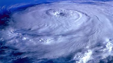
Mexico City, October 11: Tropical Storm Pamela rapidly strengthened as it moved along Mexico's Pacific coast Monday and it was forecast to become a major hurricane before hitting shore somewhere near the port of Mazatlan at midweek.
The US National Hurricane Center said Pamela's center was about 455 miles (735 kilometers) south-southwest of Mazatlan Monday and was moving northwest at about 8 mph (13 kph). Also Read | Nobel Prize in Economics 2021: David Card, Joshua D Angrist and Guido W Imbens Win Sveriges Riksbank Prize in Economic Sciences for Societal Research.
The storm had maximum winds of about 65 mph (100 kph). Pamela was forecast to take a turn toward the north and northeast, passing close to the southern tip of the Baja California peninsula late Tuesday or early Wednesday at hurricane strength. The storm was forecast to make landfall Wednesday near Mazatlan, potentially as a Category 3 hurricane. Also Read | PM Narendra Modi Reviews Agenda 2030, Climate Action, Afghanistan With UK PM Boris Johnson.
Pamela was then expected to weaken while crossing over northern Mexico and could approach the Texas border as a depression by Thursday. The hurricane center warned of the possibility of life-threatening storm surge, flash floods and dangerous winds around the impact area.
(This is an unedited and auto-generated story from Syndicated News feed, LatestLY Staff may not have modified or edited the content body)


 Quickly


