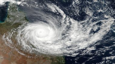
New Delhi, May 6: A cyclonic circulation formed in the southeast Bay of Bengal on Saturday, which is seen by weather scientists as the first step of the development of a possible severe cyclonic storm in the region next week.
"A cyclonic circulation lies over southeast Bay of Bengal and neighbourhood in lower and middle tropospheric levels. Under its influence, a Low-Pressure Area is likely to form over the same region by May 8," Mrutyunjay Mohapatra, Director General, India Meteorological Department (IMD) said. Cyclone Mocha to Make Landfall in Bay of Bengal; Check List of States on Alert Till May 11.
He said the details about the path and intensification will be provided after the formation of a low-pressure area. Mohapatra said the weather system was likely to concentrate into a depression over southeast Bay of Bengal around May 9 and intensify into a cyclonic storm and move nearly northward towards central Bay of Bengal.
The cyclone will be named Mocha (Mokha), a name suggested by Yemen after the Red Sea port city, which is known to have introduced coffee to the world over 500 years ago. The weather office has warned fishermen of squally weather in southeast Bay of Bengal with windspeed reaching 40-50 kmph from Sunday onwards. Cyclone Mocha: IMD Warns Fishermen Not To Venture Into Bay of Bengal From May 7.
"Those who are over southeast Bay of Bengal are advised to return to safer places before May 7 and those over central Bay of Bengal are advised to return before May 9," the weather office said. It has also suggested that regulation of tourism and offshore activities and shipping near Andaman and Nicobar Islands between May 8 and 12.
(The above story is verified and authored by Press Trust of India (PTI) staff. PTI, India’s premier news agency, employs more than 400 journalists and 500 stringers to cover almost every district and small town in India.. The views appearing in the above post do not reflect the opinions of LatestLY)


 Quickly


