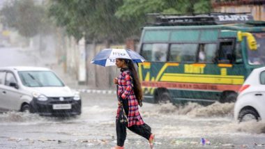
New Delhi, July 31: Heavy showers in eastern Rajasthan inundated roads and washed out rail tracks in Jodhpur division and light to moderate rains drenched the neighbouring states even as intense rainfall activity has been predicted for the next few days in parts of north and central India.
The India Meteorological Department (IMD) has issued a red alert for parts of Rajasthan and Madhya Pradesh. Fairly widespread to widespread rainfall with isolated heavy to very heavy rain is very likely over west Uttar Pradesh between August 1 and 2. Gurugram Rains: Netizens Share Pics And Videos Of Waterlogging In The City Following Heavy Rainfall.
Delhi received an average of 43.6 mm of rain till 8.30 am as the mercury reached a high of 34.4 degrees Celsius. Due to heavy rains in the last few days, a portion of a road under the IIT-Delhi flyover caved in disrupting traffic.
However, in a sigh of relief, the water level in the Yamuna river receded below the danger mark of 205.33 on Saturday morning, a day after the Delhi administration sounded a flood alert and expedited efforts to evacuate people living in the river floodplains.
The water level was recorded at 205.01 metres at the Old Railway Bridge at 8 am. It was 205.44 metres at 1 am and 205.20 metres at 6 am. On Friday, the Delhi Police started evacuating people living on the floodplains of the Yamuna in the capital as Haryana discharged more water into the river from the Hathnikund Barrage.
The weather department has issued a yellow alert in the national capital for Sunday and an orange alert for Monday. Light to moderate rain occurred at many places in Uttar Pradesh with Lakhimpur Kheri recording the highest maximum temperature of 35.5 degrees Celsius. Rainfall was recorded in Chitrakoot, Etawah, Etah, Auraiya, Firozabad, Sonbhadra, Agra and Lalitpur districts.
In Punjab and Haryana, the maximum temperatures hovered close to normal limits with some places in both the states witnessing rainfall. Chandigarh, the joint capital of the two states, recorded a maximum temperature of 35 degrees Celsius and traces of rainfall.
Widespread rainfall was recorded in eastern parts of Rajasthan inundating roads in many places and washing out railway tracks Gudha and Govindi Marwar station in Jodhpur division.
A few places in Nagaur, Baran, Jaipur, Sawaimadhopur, Karauli, Sikar, Alwar, Jhunjhunu and Churu districts have recorded heavy to very heavy rainfall till Saturday morning. A maximum of 304 mm rainfall was recorded in Baran, followed by Niwai in Tonk where 192 mm of rains were recorded.
Several roads were inundated in Jaipur, Dausa, Tonk, Sawaimadhopur, Karauli, Dholpur and Baran. In Nagaur district, rainwater washed away the railway tracks between Gudha and Govindi Marwar junction on Saturday which affected trains movement for a few hours. Bhopal-Jodhpur special train was diverted due to restoration works.
The track was restored after a few hours, a North West Railway spokesperson said. Till Saturday evening, Jaipur, Sawaimadhopur, Vanasthali in Tonk and Ajmer received 56.3 mm, 25.5 mm, 19 mm and 16.8 mm of rains.
The IMD has issued a 'red alert', warning of very heavy to very heavy rain (more than 115.6 mm) at one or two places in Baran, Jhalwar districts on Saturday. An 'Orange Alert' for heavy to very heavy rainfall has been issued for one or two places in Jaipur, Ajmer, Tonk, Sawai Madhopur, Bhilwara, Bundi, Kota and Baran districts.
Due to a well-marked low-pressure area and a monsoon trough, fairly widespread to widespread rainfall with isolated heavy to very heavy rainfall is likely over east Madhya Pradesh on July 31-August 1 and over Chhattisgarh and east Uttar Pradesh on July 31.
Widespread rainfall with isolated heavy to very heavy falls are very likely to continue over east Rajasthan and west Madhya Pradesh from July 31 to August 4 with peak activity from July 31 to August 3.
The current spell of fairly widespread to widespread rainfall activity is very likely to continue over parts of north India with isolated heavy falls over Jammu and Kashmir on July 31, Punjab on August 1, Himachal Pradesh till August 2 and Uttarakhand and Haryana till August 4, the IMD said.
P K Saha, a senior meteorologist with IMD's Bhopal office, said the red alert for five districts in Madhya Pradesh was due to a well-marked low-pressure area lying over south-west Bihar and neighbouring regions which is now likely to move west and north-west and then to the southern part of Uttar Pradesh in the next two days.
He said Sarai area in Singrauli district received the highest rainfall, of 122.4 millimetres, in east MP in a 24-hour period ending at 8:30am on Saturday, while in west MP, the highest rainfall, of 240 millimetres, was in Karahal in Sheopur.
In West Bengal, discharge of water from dams and barrages is set to increase as the storage facilities are almost full with heavy rainfall across the state for the last two days. The inflow of water is going up due to incessant rain in the state and neighbouring Jharkhand, officials said.
The West Bengal government permitted Damodar Valley Corporation to discharge up to 1 lakh cusec of water. Parts of Paschim Bardhaman, Howrah, Hooghly and Bankura districts may witness inundation if more water is released from the DVC dams, an official said.
The state government is, however, proactively opening relief camps in places that may witness floods due to the discharge of water from dams and barrages.
(The above story is verified and authored by Press Trust of India (PTI) staff. PTI, India’s premier news agency, employs more than 400 journalists and 500 stringers to cover almost every district and small town in India.. The views appearing in the above post do not reflect the opinions of LatestLY)


 Quickly


