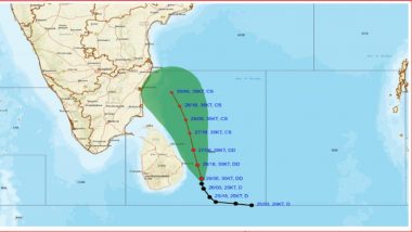
Amaravati, November 29: The deep depression brewing over the Southwest Bay of Bengal, which was initially expected to intensify into a cyclonic storm, is likely to gradually weaken into a depression as it approaches the north Tamil Nadu and Puducherry coasts. According to the India Meteorological Department (IMD), the system is likely to continue moving northwestward while maintaining its intensity as a deep depression until November 29, 2024, and then expected to weaken into a depression as it approaches the north Tamil Nadu and Puducherry coasts.
The depression is forecast to make landfall between Karaikal and Mahabalipuram, close to Puducherry, by the morning of November 30. After it reaches the coast, the system will bring moderate winds, with speeds ranging between 45 and 55 km/h, gusting up to 65 km/h, along with heavy rainfall in coastal regions. Authorities have issued advisories for fishermen and coastal residents to remain vigilant. Coastal districts in Tamil Nadu and Puducherry, particularly around Karaikal and Puducherry, are advised to expect rainfall, strong winds, and rough sea conditions as the system approaches. Cyclone Fengal Update Today: Deep Depression Unlikely To Intensify Into Cyclonic Storm, Says IMD; Orange Alert Issued for Chennai.
"The deep depression over Southwest Bay of Bengal moved north-northeastwards with a speed of 9 km/h during the past 6 hours and lay centred at 2330 hours IST of yesterday, November 28, 2024, over the same region near latitude 10.1°N and longitude 82.8°E, about 240 km northeast of Trincomalee, 330 km east-southeast of Nagappattinam, 390 km east-southeast of Puducherry and 430 km southeast of Chennai," said the IMD.
"It is very likely to move northwestwards and maintain its intensity of deep depression till 29th November. Continuing to move northwestwards, it is very likely to cross the north Tamil Nadu-Puducherry coasts between Karaikal and Mahabalipuram close to Puducherry around the morning of November 30, 2024, as a depression with a wind speed of 45-55 kmph gusting to 65 kmph. The system is being continuously monitored," said the weather department.
Earlier on Thursday, heavy rainfall due to Cyclone Fengal caused widespread damage to paddy crops in Tamil Nadu's Nagapattinam district. Cyclone Fengal News Update: Possibility of Marginal Intensification of Deep Depression Into Cyclonic Storm Between November 28 Evening and November 29 Morning, Says IMD; Heavy Rainfall Warning Issues for Tamil Nadu, Puducherry.
Paddy crops in over 800 acres of land have been completely submerged, leaving farmers in distress. The affected areas include Kamashwaram, Virundhamavadi, Pudupalli, Vedrappu, Vanamadevi, Vallapallam, Kallimedu, Eeravayal, and Chemboadi. Earlier, a senior IMD official said that there would be fairly widespread moderate rainfall in most of the parts of the state. The Indian Navy on Thursday activated a comprehensive disaster response plan as Cyclone Fengal intensifies in the Bay of Bengal.
Cyclone Fengal Live Tracker
The Eastern Naval Command, in coordination with Headquarters Tamil Nadu and Puducherry Naval Area (HQTN&P), has activated a robust disaster response mechanism to mitigate the cyclone's potential effects.Focusing on humanitarian assistance and disaster relief (HADR) and search and rescue (SAR) operations, naval authorities are working closely with state and civil administrations to ensure rapid response capabilities.
Vehicles are being loaded with essential relief materials, including food, drinking water, and medicines, while specialised Flood Relief Teams (FRTs) are being positioned in vulnerable areas. Cyclone Fengal, which is forecast to intensify within the next 48 hours, is expected to bring heavy rainfall, strong winds, and possible flooding to Tamil Nadu's coastal regions.Authorities have urged residents in low-lying and coastal areas to remain vigilant and adhere to safety advisories.
(The above story is verified and authored by ANI staff, ANI is South Asia's leading multimedia news agency with over 100 bureaus in India, South Asia and across the globe. ANI brings the latest news on Politics and Current Affairs in India & around the World, Sports, Health, Fitness, Entertainment, & News. The views appearing in the above post do not reflect the opinions of LatestLY)


 Quickly


