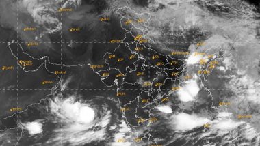
New Delhi, June 12: Indian Meteorological Department (IMD) has issued an orange alert for Saurashtra and Kutch coasts in Gujarat in view of the extremely severe cyclonic storm "Biparjoy" over the east-central and adjoining northeast Arabian Sea.
The extremely severe cyclonic storm over east-central and adjoining northeast Arabian Sea moved northwards with a speed of 7 kmph during past six hours and lay centered at 8 am on Monday about 320 km southwest of Porbandar, 360 km south-southwest of Devbhumi Dwarka, 440 km south of Jakhau Port, 440 km south-southwest of Naliya and 620 km south of Karachi (Pakistan). Cyclone Biparjoy: Very Severe Cyclonic Storm Likely to Make Landfall in Gujarat, High Waves Seen at Tithal Beach in Valsad (Watch Video).
Watch Video: High Tidal Waves Witnessed in Mumbai
#WATCH | Maharashtra: High tidal waves witnessed in Mumbai as cyclone #Biparjoy intensified into a severe cyclonic storm.
(visuals from Gateway of India) pic.twitter.com/UrnR0sahtE
— ANI (@ANI) June 12, 2023
An IMD release mentioned of storm surge warning in Kutch, Devbhumi Dwarka, Porbandar, Jamnagar and Morbi districts of Gujarat and said storm surge of about 2 -3 m above the astronomical tide is likely to inundate the low lying areas of the districts during the time of landfall. Mumbai Rains Forecast: High Chances of Rainfall As Cyclone Biparjoy Intensifies.
Watch Video: Effect of Cyclone 'Biparjoy' Seen in Gujarat
#WATCH | Navsari, Gujarat: Effect of cyclone 'Biparjoy' seen as strong winds & high tides hit Gujarat coast. pic.twitter.com/4QOIh5kZMz
— ANI (@ANI) June 12, 2023
"Damage expected over Kutch, Devbhumi Dwarka, Porbandar, Jamnagar, Morbi & Junagarh & Rajkot districts of Gujarat on June 15. Total destruction of thatched houses/ extensive damage to kutcha houses. Some damage to Pucca houses. Potential threat from flying objects," it said.
The India Meteorological Department said the cyclone is very likely to move nearly northward till June 14 morning, then move north-northeastwards and cross Saurashtra & Kutch and adjoining Pakistan coasts between Mandvi (Gujarat) and Karachi (Pakistan) near Jakhau Port (Gujarat) by noon of June 15 as a very severe cyclonic storm with maximum sustained wind speed of 125-135 kmph gusting to 150 kmph.
The weather office also cautioned about bending and uprooting of power and communication poles. It said there may be major damage to "kutcha and pucca roads," flooding of escape routes. minor disruption of railways and overhead power lines and signalling systems.
"Widespread damage to standing crops, plantations, orchards, falling of green coconuts and tearing of palm fronds. Blowing down of bushy trees like mango. Small boats, country crafts may get detached from moorings," it said and added that visibility may be severely affected due to salt spray.
Fishermen have also been issued advisory for next five days. Those out at open sea are advised to return to the coast. IMD said that along and Gujarat coast, squally wind speed could reach 45-55 kmph gusting to 65 kmph on June 12 and become 50-60 kmph gusting to 70 kmph from June 13 to evening of June 14.
"Gale wind speed reaching 65-75 kmph gusting to 85 kmph very likely to prevail from 14th June evening and becoming 120-130 kmph gusting to 145 kmph from June 15 morning for subsequent 12 hours," it said.
The weather office said squally wind speed reaching 55-65 kmph gusting to 75 kmph very likely to prevail along and off remaining districts Saurashtra coast on June 14 and 15.
It said sea conditions likely to be rough to very rough till June 14 evening and high to phenomenal thereafter till June 15 noon. The sea conditions are expected to improve after June 15.
(The above story is verified and authored by ANI staff, ANI is South Asia's leading multimedia news agency with over 100 bureaus in India, South Asia and across the globe. ANI brings the latest news on Politics and Current Affairs in India & around the World, Sports, Health, Fitness, Entertainment, & News. The views appearing in the above post do not reflect the opinions of LatestLY)


 Quickly


